
The city has nowhere to put another road
A large share of Sedona's land is federally managed forest. National Forest also surrounds the city. New cross-town roads have to contend with federal land, steep terrain, existing development, and difficult rights-of-way.
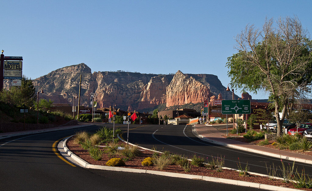
That leaves much of the cross-town traffic using the "Y," where State Route 89A meets State Route 179, a junction the city still calls a known bottleneck.
The most useful fix in years arrived in May 2025, when the Forest Road Connection opened between Uptown and 89A west of the Y, giving Uptown residents and workers a way into West Sedona without entering the roundabout.
It comes with a catch: drivers leaving Forest Road can turn only right, toward West Sedona.
The exit restriction blocks a turn back toward the Y, but the connection still carries Uptown-West Sedona trips in both directions.
And it took years of design, drainage work, retaining walls, and right-of-way negotiation to build a connection that on a flat map would look trivial.
Congestion here is also uneven in a way that rewards checking before leaving.
West 89A can be flowing freely while northbound 89A into Uptown is stacked solid.
The city added a second northbound lane between L'Auberge Lane and Forest Road and has been pushing drivers toward a zipper merge where those two lanes rejoin.
Residents who watch the traffic map or Nixle alerts before a five-minute errand aren't being fussy.
One jammed junction can ruin several otherwise short trips.
Three transit systems, and the trailheads they take over
Three transit services now cover Sedona, doing three different jobs.
The free Trailhead Routes carry people from park-and-ride lots to Soldier Pass, Cathedral Rock, Dry Creek Vista, Mescal, and Little Horse.
The schedule is generally Thursday through Sunday, roughly 7 a.m. to 5:30 p.m., with daily service added at peak periods.
Sedona Shuttle Connect is the city's $2 on-demand shared ride, covering much of Sedona, normally Thursday through Sunday, with extra days during spring break and some holidays.
The Verde Shuttle is the regional piece, running between Cottonwood and Sedona every day, roughly hourly from 6 a.m. to 10 p.m., and doubling as a local bus along 89A and 179 with stops through West Sedona, Uptown, Tlaquepaque, Poco Diablo, and the trailhead park-and-rides.
Fares are $1 within Sedona and $2 between Cottonwood and Sedona, with reductions for some riders.
They interlock. Someone can ride in from Cottonwood, transfer near a park-and-ride, and reach a trailhead without ever parking near it.
A resident inside the Shuttle Connect area can take the on-demand van for a short trip that would otherwise mean crossing a congested corridor.
Residents near the trailheads feel the consequence on their streets.
Sedona's trails are not walled off from its neighborhoods, and when the shuttle is running, the parking rules at two trailheads change.
Soldier Pass riders leave their cars at Posse Grounds rather than treating the small trailhead area as the main access point.
At Cathedral Rock, when Trailhead Route 15 is operating, the trailhead parking lot is simply closed and access shifts to the shuttle.
A road that looks ordinary on a map can end at a trailhead lot closed to public parking four days a week.
Uptown: people live behind the parking problem
Uptown's side streets absorb the spillover from one of the busiest districts in the city, and the city has been studying a residential parking permit program for Price Road, Van Deren Road, Wilson Road, and Smith Road, just off the commercial strip.
The goal is unglamorous: keep visitor and employee cars off the curb directly in front of houses.
The Forest Road Connection matters more here than anywhere.
Besides the route west, it added a shared-use path and a second access point to and from Uptown for emergency responders and evacuating residents.
A road built to fix congestion is now also a piece of emergency infrastructure.
Road work in Uptown gets staged around the fact that closing 89A in daylight is rarely practical.
In August 2026 the city scheduled nighttime road work there.
The choice is usually between daytime visitor traffic and nighttime construction noise; there is no quiet hour when the street is simply empty.
Posse Grounds does almost everything
Posse Grounds Park is far more useful to residents than the name suggests.
Its 78.63 acres hold the dog park, bike skills park, skate park, pickleball courts, disc golf, a playground, a sports field, ramadas, trails, The Hub events space, and the pavilion used for community programs.
It is also the park-and-ride for the Soldier Pass trailhead shuttle, so on a given Saturday the same site can be hosting a youth game while absorbing the visitor parking that would otherwise fill a residential trailhead street.
Its routines are unusually specific.
The dog park closes every Thursday from 9 to 11 a.m. for sanitizing, and runs 6 a.m. to 8 p.m. from April 1 through October 1, then 7 a.m. to 7 p.m. through the cooler months.
The pickleball courts, opened in late 2024, are available from 5 a.m. to 10 p.m.; organized-play blocks work differently from the usual first-come setup, and the paddles and balls live in a storage box beside Court 3.
The Sedona Community Pool sits just uphill, in a residential pocket rather than a resort district.
Its 2026 season runs May 23 through October 25, with separate lap and open-swim blocks, which makes late October a genuine cutoff on the local calendar.
Year-round lap swimmers get pointed to the Sedona Masters program once the municipal pool closes.
Evening life concentrates here as well. The Red Dirt Concert Series uses the Posse Grounds Pavilion on Friday evenings in May and again in September.
The city scheduled its free drum circle at the pavilion five times in 2026, spread from March through November.
Family Fun Fridays used the pool on June 5 and July 3, with three June nights at The Hub in between.
A Sedona address is not always the City of Sedona
The Village of Oak Creek is the distinction outsiders miss most reliably.
Plenty of addresses there read "Sedona, AZ 86351," and the community has its own branch of Community Library Sedona - but the Village is an unincorporated Yavapai County community, not part of the City of Sedona.
The line shows up in the plumbing.
Parts of the Village are served by the Big Park Domestic Wastewater Improvement District, a separate special taxing district, rather than the City of Sedona wastewater utility.
City zoning, building permits, and business-license rules follow the municipal boundary regardless of what the envelope says.
The library is one institution that makes the social boundary feel softer than the governmental one.
The main building is on White Bear Road in West Sedona; the branch is on West Saddlehorn Road in the 86351 ZIP.
A library card and a shared mailing city can knit the two areas together even where utilities, permits, and county services keep them apart.

Trash service can differ from the house next door
Sedona runs no citywide household garbage route.
Residents contract directly with private haulers from a list the city maintains, so pickup day, container setup, recycling arrangement, and price can all vary between one house and the next, or between HOAs.
The city fills the gaps with events rather than routes.
Its 2026 household hazardous-waste and electronics collection is scheduled for October 24 at Sedona Red Rock High School; a spring collection used the West Sedona Elementary School parking lot; curbside yard-waste pickup runs on date ranges assigned by zone.
The county split adds another wrinkle.
Sedona residents on the Coconino County side can use Flagstaff's Hazardous Products Center for certain materials year-round - an option a Sedona address on the Yavapai side does not automatically get.
The compost program shows how local the rules get.
Approved participants can leave food scraps at the Posse Grounds enclosure during park hours. The site sits between the tennis courts and the elementary school. Enrollment is limited to 150 full-time Sedona households; businesses, short-term rentals, and Village of Oak Creek residents are ineligible.
Fire season can delete a direction from the map
Every Sedona address sits in one of 12 evacuation zones, used with Arizona's Ready, Set, Go system, so emergency messages name zones rather than reciting streets.
The county line doesn't exempt anyone: the city's zone map covers Sedona addresses on both sides.
The 2026 Pocket Fire showed how fast the road map can change. It started in June about seven miles north of town.
State Route 89A through Oak Creek Canyon closed between Sedona and the Flagstaff side, the canyon went under a GO evacuation order before dropping to SET on June 23, and recreation sites and trails shut down.
Trailhead shuttle routes to Dry Creek Vista/Mescal and Soldier Pass were suspended during part of the response, resuming as closures eased.
SR 89A north reopened on July 13, with fire operations and recreation closures continuing afterward.
The number that mattered to residents was never the acreage.
It was that the northern route to Flagstaff simply ceased to exist for several weeks, and that canyon trips, trail access, and shuttle service all had to be checked rather than assumed.
Restrictions reach into backyards too. Sedona entered Stage 2 fire restrictions on June 30, 2026.
The city posts its own status while also directing residents to the Sedona Fire District, Coconino National Forest, and weather-service Red Flag warnings, because what's permitted can depend on exactly which land an activity is happening on.

Flooding is a street-level problem
Oak Creek makes trouble block by block.
During high water in March 2023 the city ordered evacuations around Oak Creek. The affected areas included Trails End Road, Blackhawk Lane, Copper Cliffs Drive, Sycamore Road, Oak Creek Mobilodge, the Villas at Poco Diablo, and homes north of Rancho Sedona RV Park on Bear Wallow Lane.
The city also warned that floodwater could block driveways and low-water crossings - which is often the real hazard, not the creek itself.
Back O' Beyond Road was the long-standing example.
In 2023 the city finished a concrete box culvert beneath the road. Before that, major storms could cover the crossing and leave both the neighborhood and Cathedral Rock traffic without a usable route.
Longtime residents remember the point: a short neighborhood street can become a drainage emergency before it ever becomes a traffic complaint.
Because the risk is that uneven - a house a few blocks uphill untouched while a creekside road is under evacuation order - residents have separate emergency alerts, evacuation zones, road-closure maps, and flood-hazard maps to check, while flood warnings come from the National Weather Service.
What changes, and when
- Every Thursday, 9-11 a.m. - the Posse Grounds dog park closes for sanitizing.
- Thursday through Sunday - the baseline schedule for both the trailhead shuttles and Shuttle Connect; when Route 15 runs, the Cathedral Rock lot is closed.
- Spring break and holidays - shuttle service expands beyond the Thursday-to-Sunday pattern, during some of the year's heaviest visitor traffic.
- April 1 - the dog park moves to summer hours, 6 a.m. to 8 p.m.
- Late May - the community pool opens (May 23 in 2026), summer recreation starts, and Posse Grounds fills with evening events.
- Early summer - the opposite kind of calendar arrives: fire restrictions, smoke checks, forest closures, road alerts. In 2026 the Pocket Fire closed the canyon route during the same weeks that overnight paving began on SR 179 from Red Rock Ranger Station to Chapel Road.
- October 2 - the dog park shifts to 7 a.m. to 7 p.m.
- Late October - the pool closes for the season (October 25 in 2026) while fall traffic keeps the corridors busy.
None of these dates is dramatic alone.
Together they decide whether an ordinary evening in Sedona means lap swim, a concert at the pavilion, a shuttle to a trailhead, a fire alert, or a drive timed to miss the Y.
Sources and further reading
- City of Sedona - Traffic and Roads Information
- City of Sedona - Forest Road Connection
- City of Sedona - Public Transit
- Sedona Shuttle - How to Ride and Service Details
- City of Sedona - Posse Grounds Park
- City of Sedona - Emergency Management and Evacuation Zones
- City of Sedona - Waste Collection
- City of Sedona - Community Compost Program
- City of Sedona - Short-Term Rentals FAQ
- Yavapai County - Verde Valley Precinct
Independent Publisher Notice
BestAttractions is an independent editorial publisher. We are not affiliated with, endorsed by, or acting on behalf of any location, business, property owner, manager, government agency, or organization described in this article. Comments posted on this page are not forwarded to, reviewed by, or acted upon by any entity mentioned in the article. For official inquiries, complaints, applications, bookings, or other requests, please contact the relevant entity directly through its official website or other verified channels.