Clovis, California: From Rail Stop to City
Platted in 1891 and incorporated in 1912, Clovis developed around its depot, lumber routes, and early businesses that set the foundation for Old Town and its civic identity.
The city highlights include a 1924 robbery reenacted at a bank, a wooden river flume, neon signs, farmers' markets, a rodeo, design codes, and housing plans near downtown.
A name picked at the tracks, on the neighbor's side
The San Joaquin Valley Railroad reached the farmlands of Clovis M. Cole and George Owen in 1891, laying its line along their shared boundary.
The railroad agreed to establish a stop called "Clovis," honoring local wheat grower Clovis Cole.
The Clovis Station itself sat on Owen's side of the tracks, while the townsite was mapped on December 29, 1891, by engineer Ingvart Tielman.
Early streets took the surnames of railroad backers, including Pollasky, Hughes, Osmun, Woodworth, Fulton, and Baron.
The station name was carried to the growing settlement, which was incorporated in 1912 and kept the trackside origin in its central street grid and Old Town layout.
A noon bank robbery that still gets restaged
At 401 Pollasky Ave. on February 5, 1924, two unmasked robbers entered the First State Bank of Clovis at midday, seized about 25,000 dollars, and locked the cashier in the vault before escaping by car.
The bank later closed, and the building became today's Clovis Big Dry Creek Museum.
The structure retains its original vault and period fixtures, which are used during an annual melodrama reenactment staged at the same address.
In 2024, the museum marked the heist's 100th year by staging short melodrama performances for small groups inside the former bank.
Big hats turned a work necessity into a citywide festival
Big Hat Days began in 1938 as an Old Town celebration tied to local cowboys and farm work, using the phrase to spotlight the wide-brim hats worn for Central Valley sun protection.
The tradition settled into an April weekend street fair across multiple blocks, with vendors and entertainment arranged ahead of rodeo season.
It is a two-day festival that draws large crowds to Pollasky Avenue.
The name has stayed constant through decades of format changes, linking a practical piece of ranch and field clothing to a recurring civic calendar anchor.
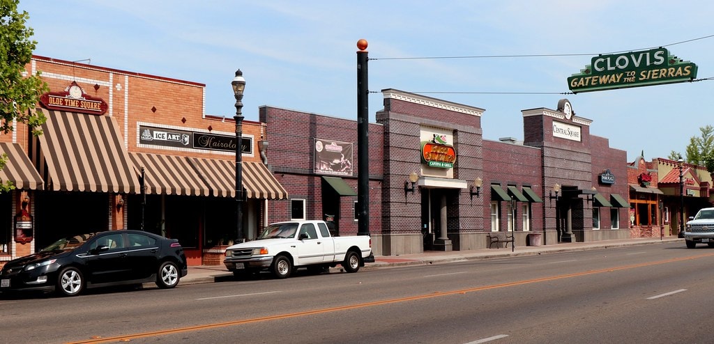
A neon span marks an older highway through Old Town
The "Gateway to the Sierras" neon sign on Clovis Avenue went up in 1940, fabricated by the Fresno Neon Sign Company.
It spanned the original alignment of State Route 168 through Old Town until the freeway bypass opened around 1999–2001.
The city removed the sign for work in the late 1980s and returned it after a restoration in 2010.
It still hangs between 4th and 5th Streets, with porcelain panels and red script recalling the road era when Yosemite-bound travelers passed directly under it.
City records place the sign among the longest-serving municipal gateway spans in the Central Valley.
A wooden river that ran 45 miles to town
A 45-mile flume carried cut lumber from Shaver Lake to finishing yards in Clovis, dropping nearly 4,900 feet in elevation.
Built in the 1893–1894 season, the V-shaped cedar trough delivered an estimated hundreds of thousands of board feet per day at peak operation.
The line ended east of the old railroad station, where the Clovis Rodeo Grounds and Clark Intermediate School sit today.
The flume's operation drew workers, homes, and services to the station area, turning a rail stop into a town.
When storms damaged sections of the structure in 1912, operations wound down, and the flume era closed with the rise of new transport and power projects in the Sierra.
A rodeo that started in 1914 and never left
The Clovis Rodeo dates to 1914, anchored at 748 Rodeo Dr. on the east side of Old Town.
It has grown into a Professional Rodeo Cowboys Association stop with multiple days of competition and a Saturday parade.
The PRCA recognized the event with a Hall of Fame induction in 2014, marking a century of continuity.
In 2024, coverage noted crowds of more than 35,000 across the weekend.
The grounds sit near the former lumber mill terminus, tying the rodeo's location to the same industrial footprint that helped create the town.
Each spring, the schedule pairs arena events with concerts and a community run.
Rails became paths linking two cities
The Fresno–Clovis Rail Trail repurposes former rail corridors into a network connecting Clovis with Fresno for about 15 miles.
In Clovis, the Old Town Trail and Dry Creek Trail form the backbone, running past parks, the Clovis Botanical Garden, and neighborhood schools.
City and trail pages list multi-use rules, at-grade crossings, and wayfinding, while maps show links to Fresno's Sugar Pine Trail toward Woodward Park.
The corridor's gradual grades and continuous pavement reflect its railroad origin, offering a direct spine from Old Town westward that avoids major arterials and ties into local bikeways.
Rails became paths linking two cities
The Fresno–Clovis Rail Trail repurposes former rail corridors into a network connecting Clovis with Fresno for about 8 miles.
In Clovis, the Old Town Trail and Dry Creek Trail form the backbone, running past parks, the Clovis Botanical Garden, and neighborhood schools.
City and trail pages list multi-use rules, at-grade crossings, and wayfinding, while maps show links to Fresno's Sugar Pine Trail toward Woodward Park.
The corridor's gradual grades and continuous pavement reflect its railroad origin, offering a direct spine from Old Town westward that avoids major arterials and ties into local bikeways.
The 1890s depot moved and became a visitor center
The small Tarpey Depot, built in 1892 on the San Joaquin Valley Railroad, was moved to Old Town and restored near the northeast corner of Clovis Ave. and 4th St. in 1999.
The wood-frame structure now serves as the city's Visitors Center, distributing maps and event information from its platform room.
Historic markers describe the depot's past roles as a passenger stop, winery office, post office, and polling place.
Western look by design, not accident
Old Town's western storefront look is guided by adopted design standards.
The city's Old Town Clovis Design Guidelines specify compatible facades, sign types, cornice lines, parapets, awnings, and materials for new construction and remodels.
Updates in 2020 refined signage, lighting, and sidewalk furniture to maintain consistent scale and visibility at street level.
Submittal requirements for the district include elevations and samples that align with these standards.
The result is a codified aesthetic that references early 20th-century commercial fronts without resorting to pastiche, keeping building forms and details consistent along Pollasky and Clovis avenues.
Free small-home plans for Old Town infill
Clovis offers pre-approved cottage home plans at no cost to encourage small-scale infill near Old Town.
The program includes several detached designs under 500 sq ft, with elevations and layouts that meet adopted design guidelines.
City materials explain permit submittals and siting, while the Old Town Clovis Development Area guidelines detail compatible massing, porches, roof pitches, and frontage patterns.
The package lowers design costs for homeowners on constrained lots, aligning compact units with the district's established forms.
Two markets, two calendars in Old Town
Old Town runs two distinct farmers' markets.
A year-round Saturday morning market operates on the Pollasky corridor, while the Friday Night market runs seasonally from mid-May through late September.
Organizers publish dates, vendor applications, and street closure details each spring.
The calendars align with other Old Town events, avoiding conflicts with Big Hat Days and ClovisFest.
Schedules emphasize farm produce, prepared foods, and maker booths, with Friday nights configured as a pedestrian evening street fair and Saturday mornings set for weekly grocery shopping and coffee stops along the same blocks.

